 OregonOutdoor Discovery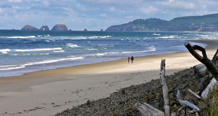
Tillamook · park · 2,014 acres
Cape Lookout State Park
4.7Google rating(2,633 reviews)
Camping open
Search to see how this park fits your needs.
At a glance
- Hours
7:00 AM – 10:00 PM daily
Visitor amenities
…stay a while
- Shelterfacility
- Accessible Featuresfacility
- Parkingfacility
- Restroomfacility
- Picnic Areafacility
- Showerfacility
…be in nature
- Wildlife Viewingnature
- Hiking Trailsnature
- Vista Pointnature
…near water
- Fishingwater
- Beachwater
…stay overnight
- Dump Stationcamping
- Campingcamping
- Cabin / Yurtcamping
…culture & learning
- Interpretiveculture
Accessibility
Structured attributes when known. Unknown stays blank — we never invent access.
- Wheelchair accessible
- Accessible parking
- Accessible restroom
- Accessible trail
- Accessible entrance
Inferred from amenities/description; confirm on official sources.
Browse wheelchair-accessible parksBest for
Suitability from published amenities — not invented by AI.
- Seniors
- seniors80
- family50
- kids40
- nature40
- toddlers33
Park size map
Official park boundary from GIS.
On the ground
Trails
Overview
About this park
A popular campground and day-use area, Cape Lookout is located on a sand spit between Netarts Bay and the ocean.
Or explore miles of ocean beaches along the Netarts Spit, north of the campground.
Construction project update Cape Lookout State Park Day-use Area and both the campground and hiker/biker camp closed on August 3, 2026 for park improvements funded by Oregon-issued General Obligation Bonds (GO Bonds).
Annual winter closures still in effect.
Construction closures will be adjusted as the construction timeline becomes clearer. Learn more Drive an electric vehicle?
See reservation button at the top of the page to reserve. 38 full-hookup sites 170 te
Things to do
Things to do
This scenic park is a destination for hiking, beachcombing and visiting sites along the Three Cape Scenic Route.
Miles of Hiking Trails The 5-mile round-trip Cape Trail features views of the ocean and shore peeking through Sitka spruce and hemlocks on the way to the tip of Cape Lookout.
On a clear day, you can see south 39 miles to Cape Foulweather and north 42 miles to Tillamook Head. The trail is mostly flat, but muddy and rocky in places.
Two segments of the Oregon Coast Trail—the North Trail and the South Trail—offer additional hiking through the forest above the ocean.
The North Trail begins in the day-use area and continues 2. 3 miles north to the Cape Trail trailhead. The South Trail continues south of the trailhead another 1. 7 miles.
For a short, family-friendly stroll, try the park’s Nature Trail, which begins near the registration booth. See our Cape Lookout Trail Guide for a hiking map.
Background
History & notes
The original acquisition for Cape Lookout was a 1935 gift of 975 acres on the cape from the U. S. Lighthouse Service. Additional land was purchase from various owners of the beach area north of the cape and the entire Netarts Sand Spit, once owned by Louis W. Hill of St. Paul, Minnesota. The Hill property was partially a gift and partially an exchange involving lands on the spit for lands at Cascadia State Park. Lands were acquired up to 1988, including a tract of 40 acres on the south side of the cape. Originally, the park was left undeveloped as a natural preserve. Sam Boardman, the first State Parks superintendent, wanted to limit development to minimal picnic use at Jackson Creek with a trail to the cape. This picnic area was developed by the Civilian Conservation Crews (CCC) during the late 1930s. A study of the park development potential was made in the early 1950s and work began in 1952. In 1954 Cape Lookout opened a small campground which grew quickly to nearly the size of today's campground by the end of the 1950s. In the early 1960s, Tillamook County built a road from the south end of Netarts Bay over Cape Lookout to Sand Lake to provide road access to the trailhead on the cape, and to the park from the south. During World War II, an Army Air Force B-17 bomber struck the cape while on coastal patrol on August 1st, 1943. It took a full day for rescue crews to reach the sole survivor. A plaque in memory of the air crew is located on the cape trail.
Today
Weather
Forecast is advisory — confirm park hours before you go.
Plan your visit
Nearby
More parks in Tillamook
Data quality
Sources
Confidence checks: coordinates · website · image · hours · amenities (and last verified when known).
Confidence score
85/ 100
Oregon State Parks
- official website
- coordinates
- amenities
- hours
- image
- last verified
Confirm hours on the official page before visiting.