 OregonOutdoor Discovery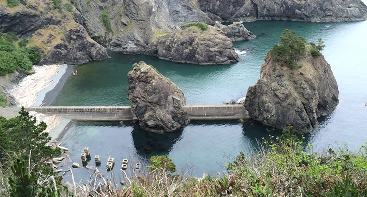
Port Orford · park · 104 acres
Port Orford Heads State Park
4.8Google rating(322 reviews)
Search to see how this park fits your needs.
At a glance
- Hours
Open for day use year round
Visitor amenities
…stay a while
- Picnic Areafacility
- Restroomfacility
…be in nature
- Wildlife Viewingnature
- Hiking Trailsnature
- Vista Pointnature
…near water
- Fishingwater
…culture & learning
- Interpretiveculture
Accessibility
Structured attributes when known. Unknown stays blank — we never invent access.
- Wheelchair accessible
- Accessible parking
- Accessible entrance
Inferred from amenities/description; confirm on official sources.
Browse wheelchair-accessible parksBest for
Suitability from published amenities — not invented by AI.
- Seniors
- Accessibility
- seniors80
- accessibility60
- kids40
- nature40
- family33
- toddlers33
Park size map
Official park boundary from GIS.
On the ground
Trails
Overview
About this park
This small park in the southern Oregon coastal town of Port Orford boasts big views and a rich wartime history.
The park preserves the site of the Port Orford Lifeboat Station, constructed in 1934 by the Coast Guard to provide lifesaving service to the southern portion of the Oregon Coast until 1970.
Besides the observation tower and boathouse, the compound included an Officer-in-Charge residence and a two-story building housing an office and quarters for the crew.
A steep stairway with more than 500 steps connected the Crew Quarters with a boathouse.
Take time to inspect the station’s legendary, unsinkable 36-foot motor lifeboat.
You can still see its pilings and breakwater structures as well as portions of a rail-mounted carriage used to launch the boats into the cove.
During World War II, lookouts worked around the clock watching for enemy aircraft, ships and submarines.
Things to do
Things to do
Hiking Trails The park’s main trails —the Cove, Tower and Headland trails—begin at the museum.
From a viewpoint on the Cove Trail, watch for remnants of the stairway to Nellies Cove. The boathouse, which sheltered two 36-foot motor lifeboats, burned down in the late 1970s.
Vistas from the Headland Trail extend north toward the Cape Blanco Lighthouse and south to Port Orford and Humbug Mountain .
The Tower Trail leads to the historical location of the observation tower, which was removed when the station was decommissioned.
Background
History & notes
Frequent shipwrecks on the south Oregon coast in the late 1800s and early 1900s prompted the U.S. Coast Guard to select Port Orford Heads as the site of a lifesaving station. From 1934 to 1970, U.S. Coast Guard surfmen, as they were called, kept watch over a 40-mile stretch of coastline between Cape Blanco and Cape Sebastian. Stationed atop a 37-foot-high lookout tower perched near the westernmost tip of the head, they watched for distress signals from out at sea, ever ready to launch search and rescue missions from their boathouse in Nellies Cove, 280 feet below. During World War II, the station’s complement grew from 13 to more than 100 Coast Guardsmen who stayed alert around the clock watching for enemy aircraft, ships and submarines. Wartime additions to the compound included a guardhouse, sentries, guard dogs, machine gun pits, and foxholes. Today, the Crew Quarters building is a museum. It is one of five surviving neocolonial buildings that comprise the historic Port Orford Lifesaving Station. The other structures are a storage building, a pump house, a garage and the Officer-in-Charge quarters, which now serves as a residence for park staff. The state acquired the property between 1972 and 1985, by purchase and exchange from private owners as well as deeds of federal surplus property. The name Port Orford is derived from Captain George Vancouver of the British Royal Navy, who in 1792 named what is now Cape Blanco for his friend, the Earl of Orford. Eventually, the name was transferred to the port some seven miles to the south.
Today
Weather
Forecast is advisory — confirm park hours before you go.
Plan your visit
Nearby
More parks in Port Orford
Data quality
Sources
Confidence checks: coordinates · website · image · hours · amenities (and last verified when known).
Confidence score
84/ 100
Oregon State Parks
- official website
- coordinates
- amenities
- hours
- image
- last verified
Confirm hours on the official page before visiting.